
Editor’s Note: The following article was originally published by Todd Miller from The Border Chronicle on January 18, 2024.
“The border has become the next war zone for the military industrial complex.”
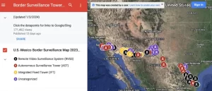
In March 2023, Dugan Meyer, a University of Arizona geographer, and Tucson-based photographer Colter Thomas began a photographic project titled Infrastructures of Control: Visualizing Security and Surveillance in the United States Borderlands. They were guided by an interactive map created by the Electronic Frontier Foundation (an organization we featured at The Border Chronicle in March). Although the Biden administration said it would emphasize surveillance technology for border enforcement in 2021, both the scope of this technology and how it looks (or blends into) the borderlands landscape are less known. Meyer and Thomas told me they found and photographed surveillance cameras in “neighborhoods, parks, graveyards, schools, water towers, and in the most remote regions imaginable.” If you examine the below map (a screenshot of the EFF interactive map), you can also see that this surveillance infrastructure is thick across the 2,000 miles of U.S.-Mexico border and works in tandem with more than 700 miles of walls and barriers and 20,000 U.S. Border Patrol agents, among other things.
And now as 2024 budgets indicate more money will be dedicated to border surveillance, and as new contracts have been issued to up-and-coming border tech companies, such as Anduril, along with the inevitable heaps of attention the border will receive in this election year, we wanted to highlight this important photographic project. We also wanted to highlight Thomas and Meyer’s observations and insights gained from doing this project, such as that “new towers are constantly being installed with no indication of stopping,” and that “surveillance doesn’t discriminate. It watches everyone and everything.” They also told me that “what we have come to realize over the course of this project is that the border has become the next war zone for the military industrial complex.”
The following photo essay begins with a question to and a comment from Dave Maass of the Electronic Frontier Foundation regarding the state of surveillance in the U.S.-Mexico borderlands today, and what we can expect in 2024. This is followed by nine photographs by Meyer and Thomas, covering border technology in different locations in the borderlands, along with captions and narration of where, how, and why they were taken.
Could you give us an overview of border surveillance tech and what we can expect in 2024? What should the public be keeping an eye on?
DAVE MAASS: The federal government has pumped hundreds of millions of dollars into the so-called virtual wall, which has resulted in a patchwork of surveillance towers, surveillance trucks, aerostats, license plate readers, unattended ground sensors, trail cameras, and who knows what else, scattered in the borderlands from the coast of California to the tip of Brownsville.
So far, with the help of Dugan and Colter, we’ve mapped out just under 400 towers, but the two of them have documented several dozen more that we’ll be adding in the coming weeks.
In 2024, we’re expecting the continued growth of relocatable surveillance towers powered by AI, especially Anduril Industries’ Sentry towers and the relocatable remote video surveillance systems (R-RVSS) from General Dynamics. One thing we want to keep an eye on is whether the tactical aerostats, originally confined to the Rio Grande Valley, are decommissioned or are expanded through the border, since we’ve received mixed messages from CBP.
PHOTOGRAPHING THE SURVEILLANCE APPARATUS
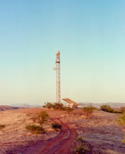
DUGAN MEYER AND COLTER THOMAS: This is the first surveillance tower we visited and photographed for this project, an Integrated Fixed Tower (IFT) manufactured by an American subsidiary of Elbit Systems, the Israeli military technology contractor. It stands southeast of Arivaca in a beautiful region of what is today southern Arizona.
Our own work to learn about and document the infrastructure of U.S. border security began when we met and realized we had similar questions about towers that we had encountered in southern Arizona. Colter, who grew up in Tucson, has been visiting the area around Arivaca with his father since he was a child, and so we started there. Looking out over this landscape, free for a moment of the geopolitical maps through which we so often view the world around us, it was striking just how invisible the border is … were it not for the steel and concrete that have been assembled into the walls and towers cutting through the grassland. And as we looked up at this tower, noting the IFT technology retrofitted onto tower hardware from the now-defunct SBInet program, we began to see something that has only become clearer as our work has expanded: infrastructure like this surveillance tower does not simply delineate or fortify the border, it is the border.
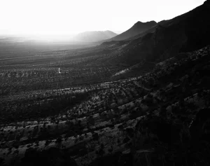
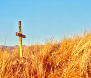
MEYER AND THOMAS: The cross in this photograph marks the location where the body of Javier Mendoza, 45, was recovered on March 8, 2021. The Pima County Office of the Medical Examiner, which works to recover and identify the remains of migrants who die in this region of Arizona, determined that Mendoza died of exposure. Mendoza is one of thousands of people who have lost their lives on the journey north through the borderlands.
His death occurred just 500 feet or so from the border wall in one of the most highly surveilled parts of Nogales, Arizona. The surveillance tower visible in this photograph is just one of three such towers that would have had a view of Mendoza’s death, which happened in a spot populated by Border Patrol game cameras and regularly patrolled by agents in trucks. In other words, every one of Mendoza’s final steps was almost certainly monitored and recorded by the U.S. Border Patrol … and yet he still died of exposure alone on this ridge.
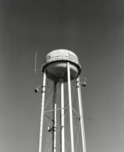
MEYER AND THOMAS: This is one of at least five (we believe there are more we have not yet located) water towers in the Rio Grande Valley in Texas that currently support Remote Video Surveillance System (RVSS) camera arrays. It is owned by the Military Highway Water Supply Corporation, a non-profit corporation supplying water for rural and domestic purposes in Cameron and Hidalgo Counties; the Border Patrol has similar arrangements with at least two other water providers in the region, Webb County Water Utilities and the Roma Water Treatment Plant.
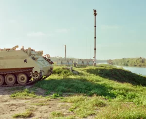
MEYER AND THOMAS: Few places along the U.S.-Mexico border encapsulate the sheer performative absurdity of our contemporary border security paradigm as well as this spot on the banks of the Rio Grande in Laredo, Texas. In addition to the two surveillance towers—inexplicably situated less than 800 feet apart, despite boasting effective ranges measured in miles—and the Border Patrol truck visible in the distance in the center of the frame, there are two tactical military vehicles sitting here as well, both silent and unoccupied. These are Texas National Guard M113 armored personnel carriers, “deployed” in this Laredo neighborhood as part of Operation Lone Star, Governor Greg Abbott’s made-for-TV, $4.5 billion (and counting) domestic military operation that has transformed thousands of Texas state troopers and National Guard soldiers into de facto immigration police. In his tweet showcasing the arrival of the M113s in December 2022, Abbott explained that they would serve as “enhanced protection for our troops in the face of increasing cartel activity.” But things seemed to work the other way around when Colter got too close to the vehicles and was warned away by two armed National Guard troops who looked to be in their teens. Why was he approaching the vehicles? To better photograph the decals that have been displayed on their sides since they arrived in Laredo: the head of a horse on one, a Trojan soldier’s helmet on the other.
MEYER AND THOMAS: As we traveled between cities and towns along the Texas border, it looked distinctly more like an occupation. Nowhere have either of us ever encountered more police—whether it was Border Patrol agents, National Guard troops, Texas Department of Public Safety troopers, sheriff’s deputies, local police officers, or a wide range of unmarked vehicles occupied by uniformed men with guns. In many places it felt as though there were more police than civilians. Encountering unmarked vehicles with uniformed armed men at every turn is a jarring experience.
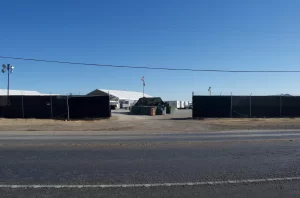
MEYER AND THOMAS: The massive deployment of National Guard troops to Texas border areas as part of Operation Lone Star has necessitated the creation of new military installations, often situated on large plots of unused land on the outskirts of town. To meet the (ostensibly) temporary housing needs in these camps, the Texas Military Department has contracted with private companies like Team Housing Solutions, whose website displays photos of its facilities for Del Rio’s Camp Amistad, which could be confused for the kinds of photos one would expect to see in advertisements for a private apartment complex. Like the Del Rio camp, the installation in this photograph—located on the outskirts of the town of Zapata—was created under contract with a private housing provider, in this case Storm Services. Unlike the Del Rio camp, however, there is no sign identifying this massive military installation that now operates out of this Texas town.
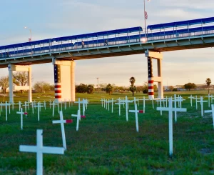
MEYER AND THOMAS: This photograph was taken in Shelby Park, Eagle Pass, which has now been partially closed to function as a 24-hour staging ground for Operation Lone Star personnel and vehicles. Colter took this photograph with his back to that section of the park, looking past a memorial erected by the Eagle Pass Border Coalition to honor migrants who have died along the border, toward a surveillance tower standing on the far side of a public golf course. Overhead is the Eagle Pass International Bridge, connecting the United States and Mexico. Visitors to this location will see a striking spatial representation of the so-called border crisis: not the front line of a war between cartels and brave American troops but parallel routes across the same river, one safe and legal for those lucky enough to have the right paperwork, and another just underneath it, this one potentially deadly and increasingly criminalized.
Note: This is an ongoing project. From now until March, Meyer and Thomas plan to visit and photograph from Nogales to the California coast. You can find all the photographs here and stay tuned for more!
El Tribuno del Pueblo brings you articles written by individuals or organizations, along with our own reporting. Bylined articles reflect the views of the authors. Unsigned articles reflect the views of the editorial board. Please credit the source when sharing: tribunodelpueblo.org. We’re all volunteers, no paid staff. Please donate at http://tribunodelpueblo.org to keep bringing you the voices of the movement because no human being is illegal.